


Choose park
Check in
Check out
Guests
Check in/out
Guests
Search
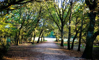
The New Forest is one of the most picturesque regions in southern England, especially as it offers an array of enchanting walks. If you're hunting for some of the best walks in the New Forest, you're in luck…

Discover the 11 best walks in the New Forest, from gentle pond strolls to challenging forest trails, ideal for families, couples, and solo adventurers.
Explore New Forest dog-friendly walks, including routes like Anderwood and Buckland Rings Trail, perfect for furry companions.
Enjoy scenic highlights such as Eyeworth Pond, Bolderwood Radnor Trail, and Exbury Gardens, offering wildlife spotting, woodlands, and open heathlands.
Combine coastal and woodland experiences with walks at Lepe Country Park and Barton-On-Sea for stunning Solent and Isle of Wight views.
Access walks easily from New Forest holiday parks, like Sandy Balls, making day trips and extended hikes convenient for all visitors.
Learn about the New Forest’s rich history and natural beauty, from Iron Age forts to ancient woodlands, while following safe, marked footpaths.
If you love wandering through enchanting woodlands and scenic trails, just imagine stepping outside your door and being surrounded by them! Explore our New Forest holiday homes for sale and see how your dream countryside escape could become a reality.
Prepare to traverse ancient woodlands, open heathlands, and charming villages – perfect for those UK holidays in Hampshire. Whether seeking a peaceful stroll by a serene pond or a more adventurous hike with your furry friend, the New Forest has something for everyone. Discover easier walks, perfect for the whole family, or some more challenging hikes if you're a couple who enjoys the challenge! It's only right to start hiking through 11 of the best walks in this beautiful landscape, home to the stunning Sandy Balls Holiday Park…

If you're looking for a walk perfect for the kids to spot some wildlife, then the Eyeworth Pond walk is the perfect choice—just under a 20-minute drive from the Sandy Balls Holiday Park!
Find out moreCreated in 1871 to supply water to a nearby gunpowder factory, it's now a lovely spot for picnics and birdwatching amidst lily pad-covered waters. After your walk, visit the renowned Royal Oak at Fritham—perfect for a family-friendly day out!
Start at the Eyeworth Pond car park: Walk along the gravel path with the pond on your left, heading into the trees.
Transition to heathland: You'll notice the trees open up to heathland, where late summer heather blooms in purple.
The path: Continue along the path until you nearly reach a road. Look for a path cutting through the heather on your right, which will then become difficult for pushchairs. If you miss the path, head across the heath toward the minor road perpendicular to the B3078.
Grassy path: Before the second road, find a wider grassy path on your right. Follow this path back to the trees.
Boggy ground: As you get back to the trees, aim for the corner of the field and walk across slightly boggy ground, keeping the field on your left. The path will become clearer as you continue through the trees to Fritham.
The Royal Oak: You'll arrive beside The Royal Oak Pub, where you can stop to refuel. Then, turn right and follow the lane back down to the pond and car park for one of the best New Forest walks!
Bolderwood is another top destination in the New Forest. It offers ample parking, facilities, and picnic tables—a great starting point for short family walks that take in the area's natural beauty! So, what are you waiting for?
Find out moreStart at Bolderwood car park: After the car park, cross Bolderwood Ornamental Drive and go through the pedestrian gate beside the cattle grid. Go right and downhill towards the deer viewing platform.
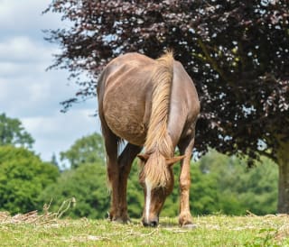
Watch out for the deer: From here, you might spot a herd of fallow deer. You can learn about the different deer species present in the New Forest.
Follow the Radnor Trail: Named after William Pleydell-Bouverie, the 7th Earl of Radnor, the trail turns right and continues downhill before it bends to the left.
Path junction: Turn right at the T-junction with red and blue markers. Follow the path downhill through an arboretum with sweet chestnut, oak, and beech trees.
Carry on the path: At a bench and blue marker post, take the right path to a junction with a red marker post, then turn left.
Stream crossing: Continue on the path, cross a stream after 300 metres, and then after another, there's a path and bench to the right. Follow the path downhill to a small footbridge over Bratley Water. Turn right after the footbridge as the route crosses Bratley Water again. Go straight, and you'll notice that the path gradually begins to climb.
Find the gate: After 300 metres, exit Bolderwood Grounds through an inclosure gate. You may spot some gorgeous deer in the sanctuary fields to your right.
Heathland views: Enjoy the views towards Bratley Wood and Bratley Inclosure. Then, you'll reach a crossroads, turning right and continuing until you reach the ornamental drive.
Back to the car park: Carefully walk along the roadside back to the car park.
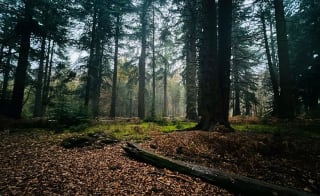
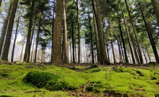
Explore the sensory trail at Forestry England's Blackwater Arboretum, home to a significant collection of trees from around the world. Along the way, you can find sensory information boards with interesting facts about the tallest, heaviest, and toughest trees. So, why not come and find out something new here?
Find out moreOak archway: Begin your walk on the Heartwood Trail by passing under the oak archway. Cross Rhinefield Ornamental Drive and continue on the gravel track before turning left onto the 'Tall Trees Trail'.
The Tall Trees Trail: Follow it through a variety of trees. Cross a small wooden bridge and follow the white-topped waymarker posts, which run parallel to the road.
On the other side, Continue to Brock Hill Car Park. Before this, the trail bends right and crosses the road. After crossing, head right, following the white-topped way markers back to the Blackwater Arboretum car park.
If you're looking for a short and easy walk, where you will see plenty of beautiful sights, like ponies grazing and the historic remains of a saltpetre house, then bring everyone along for this family adventure, so you can all experience one of the best walks in the New Forest!
Ashurst Railway Station: From platform two, follow signs for Ashurst village. Take the enclosed footpath running north alongside the railway for 200 metres. Continue straight past a gate to the public car park and road junction ahead. Turn right, then immediately left past The Happy Cheese pub. Follow the road for 160 metres to a wooden gate
Right through a wooden gate: Enter through the gate and continue along the gravel track by the former Ashurst cricket pitch. Turn right past the red brick cottage and through another wooden gate into Churchplace Inclosure, onto the gravel track through the woodland.
T-junction: Go straight as the track bends left at the T-junction and cycle post 387. Watch for deer.
Gravel cycle track: Turn right at the next T-junction and cycle post 373 to follow the gravel track for 240 metres to the wooden gate ahead.
Open forest: Turn left through the gate back into the open forest. Follow the gravel track uphill, cross the railway bridge, and go downhill to cycle post 371.
Ashurst Lodge access road: Continue gently uphill on the gravel track through Ashurst Wood, passing a low wooden vehicle barrier to join the access road. Turn right and follow the road through the woodland, past some beautiful oak trees.
Longwater Lawn: Continue straight, with views over Longwater Lawn on your left. Look for a large water trough and the earth banks of a saltpetre house.
A35: Continue to a wooden gate next to a cattle grid to carefully join the A35 and cross it. Turn right onto the footpath and cycle route, following it to the Ashurst campsite entrance.
Back to the start: Cross back over the A35 via the island crossing, just after the campsite entrance. Or, follow the pavement to the railway station. Alternatively, head straight to Ashurst Village and the bus stop.

Now, for one of the most beautiful New Forest walks, you're in for a treat, as you aren't only getting one stunning set of vistas but two! Why not combine a great walk along the Solent foreshore with an exciting visit to a woodland garden on the banks of the Beaulieu River? They are two of the best places to visit in the New Forest, so you cannot miss out…
Beaulieu RiverShore car park: Walk west from the car park, keeping left above the foreshore. Pass the Watch House and turn right at the small white lighthouse. Go up the slope, turn left, and through the kissing gate on the right. Follow the field edge, bear left through a gate, and cross the bridge.
Fields and woodland: Continue to a kissing gate alongside the fence and go straight across the field. Pass woodland and follow the path to a gap in the hedge near a pole. Cross the next field and enter the woodland. Bear right after the footbridge and turn at the waymarker post to join a fenced bridleway.
East Hill Farm: Pass the farm and follow the gravel track until it curves left. Turn right through a gate, bear left along the wide path, entering a field. Follow the right-hand field edge to a T-junction, then turn left to a stile and lane.
Time for Exbury Gardens: Go right, then through the gate beside the cattle grid, and take the footpath left through another gate to join the track to Gatewood Farm. Bear right at the fork, walk around the farm complex, and continue on the track to a gate and lane. Go straight across to Exbury Gardens – you might even want to book before you go!
Inchmery Lane: When you're ready to leave the gardens, turn right along the road. Keep ahead at the bend, where you'll see a sign for 'Inchmery Lane'. Head towards the waymarked path and stile on the left.
Grassland and woodland: Cross the stile into the grassland and then onto the woodland. Follow the path right through the trees, crossing the plank bridge with a pond on the right. When leaving the trees, turn right along the field edge beside the woodland to a gap in the hedge near a signpost. With the woodland's edge on your right, carry on until the path bears right over a footbridge into the woods. Two more footbridges will lead you to a lane via a kissing gate.
Lepe Country Park: Turn left along the lane, follow it around Inchmery House, and just before the road junction, turn right beside a barrier to the foreshore. Follow the path towards Lepe House. If the tide is out, take the foreshore route. Pass Lepe House and rejoin the outward route past The Watch House back to Lepe Country Park.

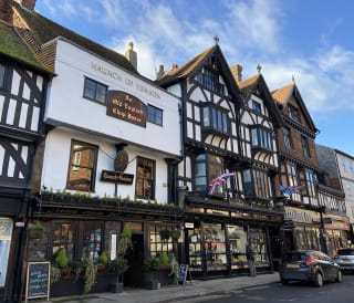
The Burley Village Walk in the New Forest is a charming stroll through a picturesque village surrounded by ancient woodlands and roaming wildlife. Perfect for all ages, it's a fantastic walk to take on when visiting or camping in the New Forest.
Leaving the village: At The Burley Inn, turn right onto Pound Lane and cross the road at the Village Hall. Pass New Forest Cider, then straight until the pavement ends at a bus stop sign and bench. Take care when crossing the road to the cycle post (153) and head uphill along Castle Hill Lane.
Burley Beacon: Look over the hedge on your left to see the large grassy meadow of Burley Beacon.
Castle Hill: Head on the uphill track. The track dips steeply after the Black Bush house and rises to Castle Hill. Take in the views from Cranes Moor to the Avon Valley and Purbeck Hills, alongside exploring Castle Hill Fort.
Spot a young oak: Go downhill until the path splits around a young oak tree. Keep on Randalls Lane, pass Randalls Farm, and cross the main road. Turn right, crossing over Coach Hill Lane and turn left on Forest Road.
The open forest: Carry along Forest Road, then over a footbridge at a Ford crossing. Continue with the open forest to your left.
Mill Lawn Brook: Look out for a low earthen mound (a Bronze Age tumulus) about 100 metres from the road on your left. When the road ends, turn right onto Chapel Lane and cross a bridge with a red post box over Mill Lawn Brook. Head straight over another bridge, past the site of Burley's first chapel.
Back to the beginning: Turn left into Beechwood Lane and continue uphill. Turn right onto Church Lane, following the gravel track through a small wood with two low wooden barriers. Continue to the end of Church Lane for views of Burley Manor. Turn left onto Chapel Lane to return to the village centre or stop at The Queen's Head pub for a bite to eat with your loved ones!
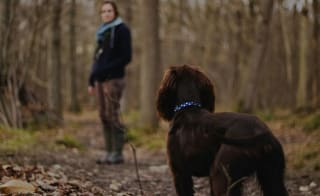
Some of these walks are perfect for the whole family, but every member has to be included, as the one in your family whose favourite thing to do (other than eating) is walking is your pooch! So, let's look at the best New Forest dog walks…
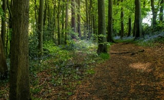
If you're looking for a family day full of picnics and exploring, the Anderwood walk is one of the best in the New Forest. It would be rude not to try this circular walk, which is accessible year-round via the cycle network.
Anderwood car park: From here, pass through the gate and picnic area. Continue through woodland, then join the New Forest cycle path.
Blackensford Brook: Turn left on the gravel track, pass Hart Hill, and cross Blackensford Brook, leading to Burley Outer Rails Inclosure.
Burley Yard: After about 2km, exit through the gate to Lyndhurst Road, where you'll cross it, then take the path beside the cottage and Forestry Commission sign marked 'Burley Yard.'
Burley New Inclosure: Pass the barrier and follow the path curving left into Burley New Inclosure. At the crossroads with marker post 116, go straight, following the path as it bends left through the Burley Old Inclosure gate.
Back to the start: Continue on the path until a 90-degree turn to the left, crossing Black Water. Cross Lyndhurst Road to return to Anderwood car park.
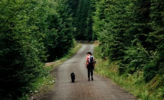
With this walk, you can choose whether you want a shorter or longer walk, so you can personalise it to suit your preferences and holiday itinerary! Based on whether your pooch is suited to shorter New Forest dog walks or longer – you can find the perfect option to suit all! Take in the stunning scenery of Ober Water and some wildlife.
Whitefield Moor car park: Starting here, find the tall wooden trailhead with an information board and follow signs down a gravel track towards woodland.
Longer trail: Turn right across the second bridge, then follow a tree-lined path. Turn right at the red-banded marker post, remembering to keep the tree line on your right, and head back to the car park over the grassy lawns.
Shorter trail: Across the heathland, carry on the path, which leads to a tree line. As you pass this, you'll be in the flat grassy areas (lawns). Go right at the marker post, following the lawn back to the car park.
Riverside walk: Follow the river through woodland, using waymarkers to avoid muddy areas. You'll see the woods slightly open out before the first river crossing, where you'll turn right and go across the wooden bridge, then follow the path onto heather-covered woodland. If you're opting for a longer walk, continue to the second bridge.
Puttles Bridge car park: Cross a wooden bridge, turn right past Puttles Bridge car park, and continue into woodland – the river will be on your right.
The nearby village of Brockenhurst is under a 40-minute drive from the Sandy Balls Holiday Park, so you can explore the beauty of it without going far! You will come across the site of a former Iron Age hill fort near Lymington and much more within yet another one of the best dog walks in the New Forest!
Iron Age history: As you walk down the lane, you'll reach Sway Lane again. Then, cross to the wooden gate opposite, which leads across fields to the Iron Age Hill fort.
Buckland Manor Farm: Carry on the path south, then cross Sway Road towards Lymington. At the small junction near Yaldhurst Copse, go right (not over the bridge) and continue straight through Buckland Manor Farm.
The Serpentine: After exiting the farm fields, turn left onto Mount Pleasant Lane, go down it, and then right down a short lane (buildings on the right). Continue straight on the public footpath through a small wood to fields. Exit them, up the track, and turn left down the public footpath, also known as 'The Serpentine'.
Mount Pleasant Farm: Continue on Shirley Holms Lane, bearing slightly right (not straight over the cattle grid). Follow the track past houses to a public footpath leading to Mount Pleasant Farm.
Jealous Lane: Follow the enclosed footpath to the New Forest. Veer right around houses, then left onto Jealous Lane, over the top of the railway line. Take a sharp right after the houses.
Take a well-deserved break: Turn left and walk to the Rosie Lea House for a stunning break. After you've finished refuelling, stand at the Rosie Lea House and look across the road to find the small path. Cross the A337 carefully.
Sandy Down: Exit through a wooden kissing gate onto Sandy Down Lane. Cross straight and go through another gate. The path goes south, crosses Lower Sandy Lane, and heads down. It goes over a footbridge, then up across fields before reaching the A337.
National Nature Reserve: Continue on the bridleway south into Roydon Woods. Carry on straight, then turn left onto a vehicle track through the woodland. At the next junction, go straight. Take the right-hand fork when the path splits, leading to fields and then Sandy Down.
Church Lane: Walk down this lane, passing the church on the left. The lane bends right, with a farm on the right and fields to the left. Take the public bridleway track between the fields.

For a coastal walk with views across to the Isle of Wight, head to a popular place to take in everything that the beautiful UK offers you at Barton-On-Sea! You and your pup won't be disappointed, especially if they love to splash about in the water…
Find out moreCoastal Path to the start: At the far-left corner of the car park, follow signs to the coastal path, and turn right while keeping the sea on your left. Continue alongside Beckton Bunny chine to a path junction, then bear left to follow the coastal path back to the start.
Danes Stream: Turn right on Downton Lane, then right through a kissing gate. Follow the track, turn left through another kissing gate, and follow the edge of the woods, bearing right down to a footbridge. Cross Danes Stream, continue through the field, follow the left-hand fence to a kissing gate, and then up the steps to the road (B3058). Turn right, then left into Taddiford Gap car park (alternative start).
The Royal Oak: Turn right on the road, then left on Angel Lane. After Angels Cottage, turn right through a gate and cross a large field to the southern corner. Enter the woods, and turn left at the track, keeping straight (yellow marker). Cross a footbridge, continue across the field, leaving the trees, and go through a kissing gate. Turn right along the road to the Royal Oak.
Barton Common: At the far right-hand side, cross Becton Lane, turn left for 50m, then take the right fork through the trees, soon forking left to reach a road and a parking area (alternative start). From there, enter the gate, follow the path along the left edge of Barton Common and exit through a northern edge gate.

It's time to discover the beauty and diversity of the parish all year round. For your summer holidays, witness the sun beaming off the grass, and during those colder months, enjoy frosty morning views; for those romantic holiday walks, this last entry is on the list of the best walks in the New Forest!
Are you ready for all the walks you can take in the New Forest, whether with your loved one or New Forest dog walks? For a little more insight, here are some of the most frequently asked questions so you can fully prepare for your next adventure!
There are so many different places to hike in the New Forest, including:
Barton-On-Sea
Eyeworth Pond
Burley Village
Ashurst
Anderwood
You can walk anywhere in the New Forest, but remember to stick to footpaths and tracks to avoid disturbing natural habitats and wildlife and follow the New Forest code and New Forest dog walking code. With 140 miles of footpaths available, there are many options for exploring the area.
The highest point in the New Forest is Piper's Wait, near the lovely village of Nomansland in the Northern Forest. It stands at around 140 metres above sea level—yes, you read that right!
There are many places to park for walks in the New Forest, so you are always close to your next adventure. Click here to find the closest one for your chosen walks.
You should be equipped with everything you need to find some of the best walks in the New Forest in Hampshire. Now, all you need to do is get some walking gear and book your next holiday so you can experience everything the stunning New Forest offers for everyone – both humans and pooches will never want to leave! Don't miss out on our latest static caravans for sale in the New Forest too.
Whilst you wait... just think about being in your swimmers, the sun's out and the smiles are big
Enter your details to make a payment or request a change
Don't remember your details? Check your confirmation email, or speak to our team
Are you an owner with us? Click here to login