


Choose park
Check in
Check out
Guests
Check in/out
Guests
Search
Whether you want to visit Snowdonia and all it has to offer, Point of Ayr, or Great Orme, you can do all of that and more with some of the best circular coastal walks in North Wales.

Diverse Circular Walks: From family-friendly strolls to challenging mountain routes, North Wales offers 13 scenic circular coastal walks for all abilities.
Stunning Coastal Views: Enjoy panoramic vistas of Snowdonia, the Llŷn Peninsula, Great Orme, and the Menai Strait along these varied trails.
Historic & Cultural Highlights: Walk past ancient castles, lighthouses, historic towns, and heritage sites like Flint Castle, Wat’s Dyke, and Aberdaron’s old mill.
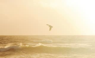
Wildlife & Nature Encounters: Spot wading birds at Point of Ayr, explore tidal estuaries, woodland paths, and nature reserves along the North Wales coast.
Accessible Holiday Bases: Many walks are conveniently near top holiday parks, making it easy to plan a walking-focused North Wales getaway.
Flexible Distances & Difficulties: Walks range from short 2–3 mile easy loops (Aber Falls, Conwy Mountain) to full-day adventures over 20 miles (North Wales Path, Abergele to Pensarn).
If you’re in love with the stunning coastal walks of North Wales, imagine stepping outside your door straight into that breathtaking scenery! Explore our North Wales holiday homes for sale and see how your dream seaside escape could become a reality.
No matter who you’re travelling with, you can find some of the best walks to suit you, which are perfect to fit into your North Wales holiday. Luckily, you can find some of the best holiday parks to accommodate this too, whether you decide to bring the whole family, including your dog, or you want to travel solo. North Wales offers an abundance of beautiful scenery to take in and plenty of mountains that you can discover with these walks, so what are you waiting for? Let’s delve into them…
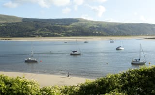
Starting strong, this circular coastal walk in North Wales offers panoramic views of the Mawddach estuary and Llŷn Peninsula. It climbs behind Barmouth to the Panorama Walk, then crosses farmland and descends through woodland back to town.
Find out moreIt’s a must-see (and walk) location – one of the best and most popular places in North Wales, plus it’s home to Barmouth Bay holiday park!
Length: 5.6 miles
Difficulty: Moderate

Along the Wales Coastal Path, you’ll circle the Great Orme near Llandudno, making for a scenic and relatively easy walk that can be completed at a leisurely pace:
Find out moreLength: 5.4 miles
Difficulty: Easy-moderate
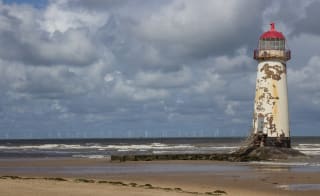
The Point of Ayr marks the northernmost point of mainland Wales, where the golden sands of northeast Wales meet the estuarine mudflats of the River Dee. In the winter months, this area attracts huge numbers of waders and waterfowl.
An 18th-century lighthouse stands at this location, making for one of the best circular walks in North Wales! It is a perfect walk for families – remember to bring your binoculars for some bird spotting, where the kids can get up close and personal with nature…
Length: 3 miles
Difficulty: Easy

This approachable circular walk at Conwy Mountain makes a great addition to visiting Conwy's historic town walls and castle. The route quickly ascends to the summit ridge, rewarding you with coastal and Carneddau mountain views…
Length: 2.8 miles
Difficulty: Easy

Nestled in the northern Carneddau foothills of Snowdonia, Aber Falls is one of the region's most dramatic waterfalls.
Find out morePart of the Afon Goch's (Red River) final descent to the Menai Straits, the river plummets an impressive 120 feet, crashing into a shallow rocky pool before flowing on towards the village of Abergwyngregyn. Aber Falls is one of Snowdonia's most impressive and accessible natural wonders and one of the region's shortest walks, so it's an excellent introduction to the National Park's unique attractions!

Showcasing the diverse beauty of the Llŷn Peninsula and its designated Area of Outstanding Natural Beauty, this circular coastal walk in North Wales is the perfect choice!
You'll discover both the northern and southern coastal paths, embark on a gradual climb up the slopes of Mynydd Anelog for panoramic views, and return through agricultural farmland and the Afon Daron Valley.
Length: 9.3 miles
Difficulty: Moderate-challenging

Offering a wealth of historical sites, including Flint Castle, Basingwerk Abbey, the holy well of St Winefride, and the ancient Wat's Dyke earthwork, come witness this piece of history with one of the best circular coastal walks in North Wales!
Follow the Wales Coast Path from Flint Castle towards Basingwerk Abbey, enjoying some stunning views out over the River Dee.
Once you pass by the Abbey you’ll turn inland through the Greenfield Valley Heritage Park towards Holywell. Then follow the Wat's Dyke Way back to Flint.
Wat's Dyke is believed to have been built around 820 AD by the Mercian king Coenwulf to protect his lands from Welsh raids. Though an impressive engineering feat at the time, the remains of Wat's Dyke are now often hard to discern along the Wat's Dyke Way route that follows its path.
Length: 7.8 miles
Difficulty: Moderate-challenging
This full-day walk combines three long-distance footpaths – Offa's Dyke, North Wales Path, and the Wales Coast Path. So, why not take a day out of your North Wales holiday to experience one of the best circular coastal walks in North Wales?
Find out moreStart inland where the route passes through Prestatyn's residential areas before climbing steeply uphill towards the Prestatyn Heights Nature Reserve, reaching over 200m in elevation.
Continue onto Dyserth, where you'll find the remains of a castle constructed by Henry III in 1241, later destroyed by Llywelyn ab Gruffudd in 1263 after a prolonged siege. Or, why not visit the more easily accessible Dyserth Falls?
The North Wales Path then leads to Rhuddlan Castle, built by Edward I in 1277-1282. The final section follows the North Wales Path along the Afon Elwy banks to rejoin the coast at Foryd Bridge between Kinmael Bay and Rhyl, which is also home to Golden Sands Holiday Park.
Length: This walk will take a full day
Difficulty: Moderate
This circular walk follows the North Wales Path along the coast to Llanddulas, then returns through the countryside and woodlands south of the town.
Length: 2 miles
Difficulty: Easy

Explore the landscapes of the Llŷn Peninsula, from the charming Victorian seaside village of Borth-y-Gest, through a wooded nature reserve with sweeping Cardigan Bay views. From the historic Georgian village of Tremadog and the bustling harbour town of Porthmadog, home to narrow gauge railways and the famous Cob crossing, discover one of the best circular coastal walks in North Wales!
Find out moreLength: 6.3 miles
Difficulty: Moderate

This short, scenic walk showcases Aberdyfi's highlights – a stunning sandy beach, the site of a medieval castle, sweeping views of the Dyfi estuary, and more. The route starts and ends in this picturesque seaside town.
Length: 4.6 miles
Difficulty: Easy-moderate
This scenic walk includes a coastal stretch overlooking the Lavan Sands and Anglesey, as well as a climb up the slopes of Moel Wnion on the Carneddau range. Spot wading birds along the shoreline, and enjoy panoramic views of the Menai Strait and Anglesey from the higher sections. A rewarding route blending natural beauty and historic interest.
Length: 6.3 miles
Difficulty: Challenging

It’s time to explore the hidden history of the landscape above Penmaenmawr and witness the abundant birds and wildlife species you may see on your walk…
Find out moreLength: 5 ½ miles
Difficulty: Moderate-challenging
Here are some frequently asked questions about circular walks in North Wales:
If you like the sound of the North Wales coastal path, the start and end points of the Wales Coast Path depend on the section you're walking from.
In the north, the path begins on the border with the English city of Chester, connecting with National Cycle Route 89.
In the south, the path terminates in Chepstow, near the town's bandstand. The official halfway point of the entire Wales Coast Path is located in New Quay, Ceredigion.
How long does it take to walk the whole Welsh coastal path? How long it takes to walk the whole Welsh coastal path depends on what type of walker you are. An average for a dedicated walker is 6-7 weeks. However, you can split this up to suit your North Wales holiday.
One of the best parts of the Wales coastal path is the Pembrokeshire Coast Path - the longest section of the Wales Coast Path, spanning 182 miles. It is also arguably the most popular, having attracted hikers and ramblers with a fondness for coastal breezes ever since it was designated as a National Trail back in 1970.
However, here are some of the other best parts of the Wales coastal path:
There’s one last thing missing from this list and that’s a circular coastal walks in North Wales map to help you on your journey.
You can find exactly where these walks are and how far away they are from your chosen holiday park here!
Setting you up for your walking holidays ahead, why not book your next one now?
Whilst you wait... just think about being in your swimmers, the sun's out and the smiles are big
Enter your details to make a payment or request a change
Don't remember your details? Check your confirmation email, or speak to our team
Are you an owner with us? Click here to login